
A drone flight can produce thousands of images, an orthophoto, point cloud and mesh. Those deliverables are valuable, but a working spatial system must also know which real-world objects they describe and how those objects changed.
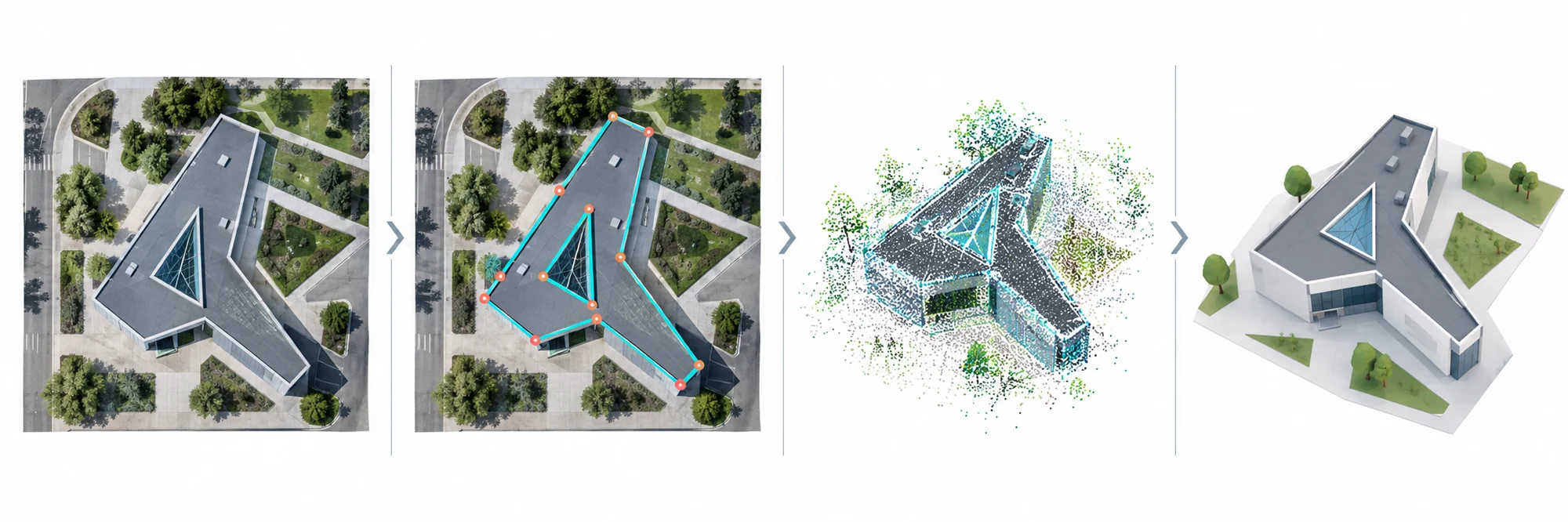
*A useful pipeline preserves the path from source capture to proposed and verified entities.*
Table of contents
- The file-delivery problem
- Stage 1: capture with context
- Stage 2: reconstruction and quality control
- Stage 3: observations and candidates
- Stage 4: identity matching
- Stage 5: versions and evidence
- Stage 6: from Viewer to action
- Where automation stops
- Frequently asked questions
The file-delivery problem
Traditional workflows often end when files are uploaded. The next survey creates another folder, and comparison depends on filenames or manual overlay. Buildings, roofs and issues do not have stable identity across deliveries.
This limits search, automation and long-term value. A mesh can show the site beautifully without answering which building it represents, which date is authoritative, what changed, or which task followed from the change.
Stage 1: capture with context
The pipeline begins before takeoff. Preserve the mission plan, aircraft and camera metadata, coordinate system, control and check points, weather, operator, permissions and intended use. Source imagery should remain immutable and traceable through checksums.
Capture design must match the target. Roof reconstruction, facade inspection, progress documentation and marketing imagery require different coverage. A technically successful flight can still be unfit for the intended analysis.
Stage 2: reconstruction and quality control
Processing may create camera poses, dense points, a mesh, orthophoto, elevation products and quality reports. Keep the processing software version and settings together with residuals and coverage information.
Quality control should test independent checkpoints, gaps, blur, surface noise, scale and coordinate consistency. A reconstruction that completes without an error is not automatically accurate or complete.
<figure><img loading="lazy" decoding="async" width="1320" height="1240" src="/media/insights/mesh-to-architecture-comparison.webp" alt="Eight comparisons between a photogrammetric mesh and a simplified architectural model of the same building"><figcaption>A Skylens experiment turning mesh observations into editable architectural geometry. The visual matches are workflow outputs, not proof of metric accuracy without control points and measurements.</figcaption></figure>
Stage 3: observations and candidates
Algorithms can extract roof masks, planes, ridges, facade regions, equipment and change candidates. These outputs are observations linked to the reconstruction and source evidence.
They should carry geometry, class, confidence, method, time and processing version. Unknown areas and incomplete coverage should remain explicit. A candidate roof plane is not yet an approved architectural roof entity.
The same principle applies to change detection. Different lighting, vegetation, construction equipment and reconstruction artifacts can create visual differences that are not physical changes.
Stage 4: identity matching
The system compares new candidates with existing entities using location, overlap, topology, parcel context, attributes and temporal continuity. The possible outcomes include a confident match, a proposed match, a new candidate entity, a split or merge case, and required review.
Identity should not depend on a single model file. A stable building ID can connect many flights, point clouds, models and observations. Read why an AI mask is not a building entity for a deeper explanation.
Stage 5: versions and evidence
An accepted update creates a new dated entity version; it does not erase earlier states. The record stores what changed, which source supports it, which process produced it and who approved it.
This enables comparison and audit. A team can inspect the current roof geometry, return to the preceding version and open the images or points that justify the update.
Stage 6: from Viewer to action
The Viewer should connect selected geometry to context. A user can open the building, switch capture dates, inspect evidence, compare models and create a task or issue tied to the same entity.
In Skylens Viewer, a drone survey can therefore become part of a project timeline rather than a standalone deliverable. The value grows when later captures update the same spatial record.
Where automation stops
Automation is well suited to repetitive proposals, candidate ranking, geometric comparison and quality flags. It should not conceal missing reference information or automatically certify a material change when evidence is ambiguous.
Human review is especially important for persistent identity, topology, legal boundaries, safety-relevant findings and geometry used for engineering or payment. The interface should show the source and uncertainty needed to make that review efficient.
Frequently asked questions
Should every drone flight update a digital twin?
Only when the capture has a defined purpose, adequate quality and a controlled relationship to the project record. Marketing flights may remain media assets; survey flights can support structured updates.
Is a 3D model always required?
No. Orthophotos, images or point clouds may be sufficient for some questions. The entity and evidence model should support the source best suited to the task.
What is the difference between visual change and verified change?
Visual change is a detected difference between sources. Verified change is a project conclusion supported by registered evidence, quality checks and the required approval.
How can a team begin with existing data?
Inventory the files, dates, coordinate systems and project identifiers. Establish canonical entities, link the most reliable sources first and preserve unresolved matches for review.
From one-off delivery to spatial memory
The pipeline changes the product from a folder of outputs into a maintained record of the site. Each capture adds evidence and a possible new state, while stable entities preserve continuity.
Learn about drone photography and mapping, explore 3D mapping, or contact Skylens to plan a recurring capture workflow.